


Preliminary description of the continuation of my solo canoe journey along the water route of the Ca
- Jan 5, 2016
- 19 min read
In September, 2015, I added another leg to my solo canoe voyage along the historical water route of the Canadian fur trade. This covered the stretch from Waterfowl Lake (or also Fowl Lake), where I had been forced to abort and return back in June 2013, to Fort Frances. The chain of lakes and rivers that I followed and connected by more than forty portages defined today's boundary between Canada and the United States. The original intent in the border definition had been to facilitate a free access from both countries to travel along the route. At the present time, I have started describing the course of this adventure in English. I am offering here what I have written so far. I will be adding new parts as my writing progresses.
RETRACING CANADA'S HISTORY
Continuation of the solo canoe journey following the historic water route of the Canadian Voyageurs from Waterfowl Lake (also North Fowl Lake) along the water
route-defined Canada/US border to Fort Frances (August 31 – September 19, 2015).
Jan Soukup

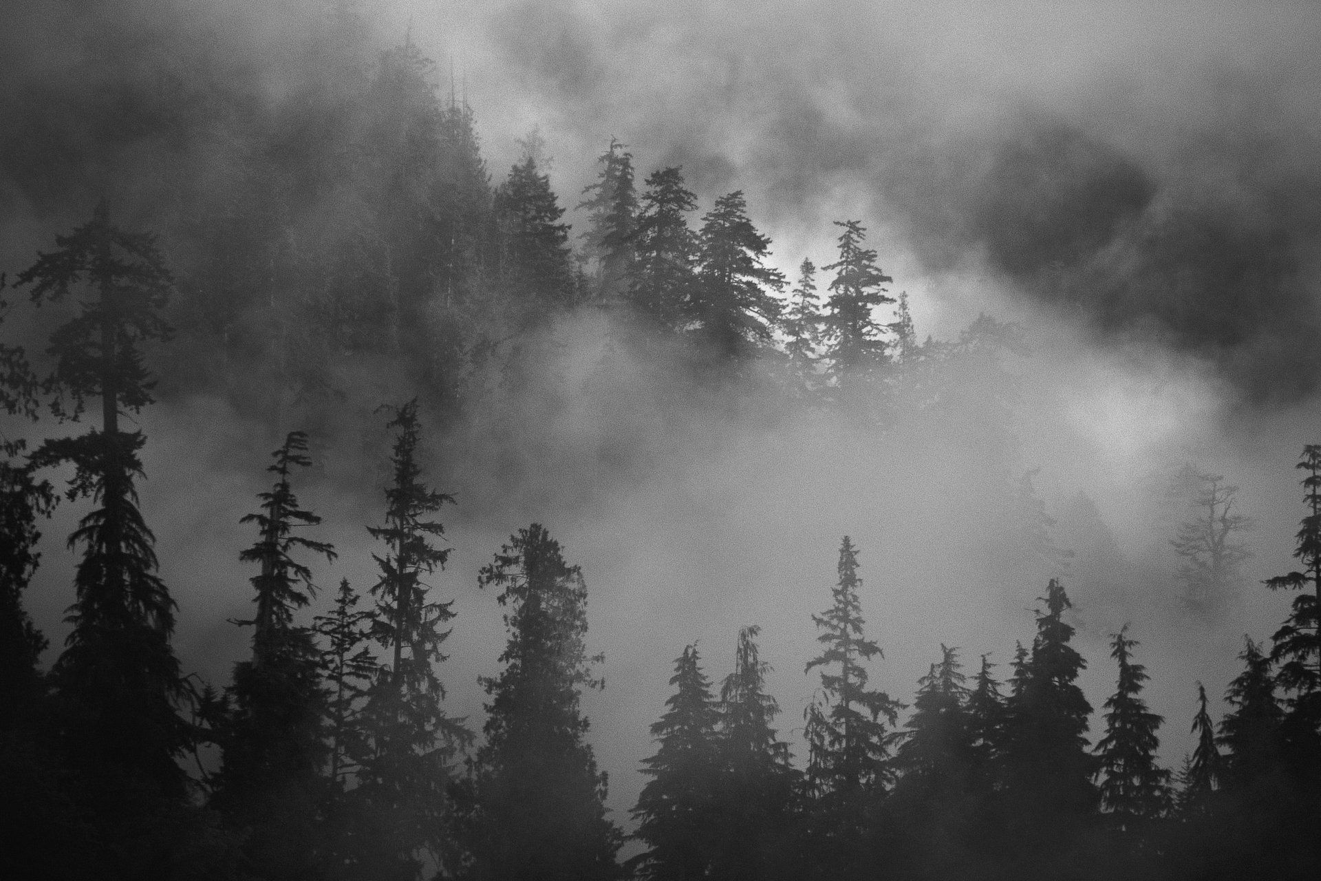
My "back-country" camp on the Canadian side of Mountain Lake along the canoe route of the Boundary Waters in Sep. 2015.
„Oweeee!!!!“ – a scream pierced the silent darkness of a late evening. Its gravity got legitimized by muscle tissue-muffled thuds of a human body collapsing into the kitchen floor tiles. Sitting in front of a computer in the ground floor office, I had no idea that Milena was returning from the upstairs bedrooms to join me. Allegedly, she wanted to help me check, which items on a predetermined list still remained to be added to an already packed gear for our very challenging canoe expedition. We had planned it for over a year and were to depart for it in two days. It turned out that after an evening bath and application of complexion creams, Milena was descending in her nightgown and raised heel slippers down the carpeted stairs - in darkness! The fate struck on the second last step, when her instep slipped sideways in her slipper and got violently twisted into a position, in which it wasn’t meant to function in any other way, than to drop the rest of the body as an undercut tree. The first was an instinct reaction - a response to the sharp pain - with attempts to assess the level of injury. But soon followed the reaction of a cool reason, as to what impact could this unfortunate accident have on our plans. Unwilling to accept the thought of cancelling our ambitious project, Milena bravely stood up and tested, if she could put weight on the effected leg. She hoped that this would turn out to be just a severe sprain, something that might, perhaps, postpone our expedition a bit, but not cancel it. Yet, the X-rays at the Emergency the next morning, painted a different picture. It showed that Milena fractured the navicular bone in her foot – a diagnosis that eliminated any possibility of her tackling the forty difficult portages that the route of our planned travel through the lake country wilderness involved. Don’t they shoot race horses when they suffer this kind of injury? Milena‘s leg went into a cast and her spirit sank into a deep depression. She feared that I had to be disappointed, and although I assured her that everything was O. K. that this was simply fate, that things happened for a reason and you could not do anything about it, my mood was low from the inability to resolve anything.
When I aborted my canoe voyage across Canada along the water route of the Voyageurs at Waterfowl Lake in June, 2013, I determined then that to continue on, among other factors without a partner, was too dangerous. But when during the whole next year, I had not found any, it was just Milena again, who voluntarily stepped by my side, offering to accompany me as a partner. I valued that gesture strongly, but I worried that this kind of undertaking could be somewhat over her head. Yet at the same time, I fully realized that I would have a hard time finding a better partnership. I had known Milena well and I knew that in critical situations, she would able to mobilize all the abilities that she had to her disposal, focusing them towards a positive outcome. I knew that she would never panic. Didn’t we successfully complete a trek with a canoe over the mountains of the Continental Divide to the Nahanni river in Northwest Territories together in ’97? Haven’t we together descended the rivers Tsichu, Keele and Mackenzie in the Northwest Territories completely alone and trekked back to our vehicle in Yukon along the Canol Heritage Trail in `99? Following my initial doubts, it was quite clear to me that Milena didn’t view her offer as some heroic sacrifice, or an attempt to somehow prove her faith and love. It was obvious that she was genuinely looking forward to the adventure. The preparations thus started already a year in advance. Sometimes during November, I discovered a new tandem canoe for us in the Edmonton Mountain Equipment Coop store. It was hanging on the wall, smiling at me with its slender shining yellow hips right from the moment, when my eye roved over it. It was a love at first sight. The canoe had a classical “Prospector“ shape and it was made by the same manufacturer, who produced my thoroughly test-proven solo canoe. It was made from a yet lighter Kevlar and thus, although a whole seventeen feet long, it weighed even less – 20.5 kg. It was again adorned with a splendid ash woodwork, including an artfully sculpted center yoke for its most comfortable carrying behind the neck on the shoulders. Its original price was no less than $3300, which posed a high enough barrier for me to forget about it. But as I continued to visit the store during the winter, I noticed with a surprise that after Christmas, the price started to drop. The store was to receive a new shipment of boats in the spring and it needed to make room for them. I entered into a kind of poker game with the store, by cautiously postponing the purchase. When, at last, the price dropped to $2200, I was ready to close a deal. Only, as a last minute prank, I proposed a very improbable offer of $1800 and, to my shocked surprise, the sales person accepted it. After its transportation home, around the new canoe still remained a lot of work. A new spray cover had to be designed and sewn for it – already our fifth. This meant to source out waterproof Life Jacket Nylon, to drill a row of small holes on each side of the canoe and pass through them nylon cord loops glued from the inside for the lacing on of the spray cover. We managed to overcome all related snags and pitfalls and complete the task less than a week before the planned departure. And now, this!
Milena was given a sick leave from her employer and I was racking my brains trying to come up with some idea of how we could use her time off together. It would have been nice, if we could spend the Indian summer at the log house on Kootenay Lake in B.C.. Alas, the conditions of the sick leave stipulated that Milena was not to leave Edmonton. Even if I wanted to, I alone could not leave her for a few days either, because, as long as she had a leg cast, she could not drive. Ergo, I had to be constantly on hand, to drive her to checkups and for unforeseen incidentals. Only after the cast had been removed and the doctor suggested that Milena should start cautiously walking on her leg and drive, I made a spur of a moment overnight decision. I would head out and continue in the Voyageur route alone again – solo. Everything had been ready for two weeks. What only remained, was to replace the tent and the canoe with the solo kind. Small repairs that my solo canoe required took me only one day. By now, it was the end of August - the time for the realization of the trip was quickly passing away.
My flash decision filled me with fear. Am I not contemplating to return to where I considered my situation lethal two years ago? Moreover, I did not even know, if I would succeed in getting my gear and myself to Waterfowl Lake, the location from where I turned around to go back at the time. While pouring over the terrain around Waterfowl Lake in Google Earth, I finally discovered a spot on its Canadian shore, where in the maximum zoom-in, four wheel drive trucks and all-terrain vehicles appeared parked in the shade of the trees, together with motor boats and boat trailers. They hinted to me that there must have existed a way to get to the lake from the Canadian side, which would allow this kind of vehicles an access. Indeed, I was then able to trace a mud, or gravel track on the screen that was disappearing and reappearing from under a forest canopy having peeled off a small paved road. “There is my only hope!” I concluded. On it, I should be reliably able to get to the lake in my Jeep Wrangler with the canoe on its roof. But to leave the Jeep unattended in the middle of nowhere for maybe even a month? And how am I supposed to get back to it from Fort Frances, after I finish my canoe voyage there? I was prepared to pay generously to my Good Samaritan Aaron, who provided me with the transport to Lake Superior and stored my vehicle in Thunder Bay two years ago. But he was now finishing his master’s degree at the university and couldn’t free himself for the service. In spite of keeping several „irons in the fire“ represented by promises from friends to find something for me through their acquaintances in Fort Frances, nothing materialized in the end. Finally, I again turned to the electronic friend – the World Wide Web. I managed to find two taxi companies in Fort Frances, who were both willing to take me to Waterfowl Lake, even though they had never heard of it and didn’t in fact know, what they were getting into. The problem was, though, that the price for the service was on the level of taxi fares and for the several hundreds of kilometers, this was really high. The first company had a standard price of $500 for the trip from Fort Frances to Thunder Bay. My lake was situated another 150 kilometers further south on the border and consequently, I should have expected a total sum of some $700 to be brought to it. Besides that, I was to pay another about $100 for safekeeping of my Jeep in Fort Frances. When I mentioned to the second cab company, which had been in a constant competition with the first one, that I had another option, its owner immediately offered that they would take me to my destination for a flat fee of $500. Without much hesitation, I accepted the offer on the phone. We were to meet early the next morning at the parking lot of the Gold Star Taxi. During the night in the motel, however, I hardly slept. The stress from the uncertainty of the success of the operations would not let me sleep, nor eat. Through the whole night, I was thinking. The Gold Star were planning to use just a regular Chrysler minivan with a front wheel drive. It had no roof rack and thus we would spend a lot of time in untying my canoe from my Jeep and tying it in an improvised way onto the rooftop of the minivan. Besides that, I wasn’t even sure, if we would find the way to the lake at all.
In the morning, I turned up in the taxi company’s parking lot almost still in darkness before six o’clock. Its owner, Doug, already waited there prepared with a Dodge Caravan. We introduced ourselves to each other, shook hands and I revealed a bold plan, which emerged from my sleepless meditations: “Doug, look, this Jeep would have no problem making it to the lake. The canoe is already reliably affixed to its roof. The gear is inside, the tank is now full of gas. If we drive in it together to the lake and you then return with it to Fort Frances, I will pay you $200. If you park it at your house and guard it there until I reappear in town by canoe, I will pay you yet another $60. What do you say? “ There was no problem. Doug immediately agreed. It was likely that he had been in fact worried about his vehicle. Without delay, we jumped into the Jeep and started out. I was driving and maintained a conversation for the long hours of traveling along the highway in the direction of Thunder Bay. Doug didn’t do much talking. He was of roughly my age, a slender cowboy type, apparently a heavy smoker. In Kakabeka Falls, we turned south and followed now already secondary paved roads in the direction of the border. The settlements along the way gradually petered out until we finally drove through vast forests on a pavement that seemed to be only wide enough for one vehicle. I correctly turned off onto a gravel road at the right moment and, after crossing a small river, I followed an arc of the road, which was curving in the right direction. These roads no longer showed on the map and the electronic navigator on the screen of my Jeep displayed only the arrow of my position that was hovering in empty space. I knew that we should arrive to a fork in the road, where we were to choose its left branch. A turn-off from it to the right should then appear after some distance and this was already supposed to lead to the lake. The fork in the road indeed soon appeared. Its left branch seemed to be well traveled and that we now followed. After some while, a right turn-off really appeared and, even though somewhat faint, we turned onto it. The new track turned very rough, going through rugged terrain. The Dodge Caravan would have hardly coped with it. The turn-off, however, curved into a wrong direction after a while, it started steeply climbing and in the end it petered out. We were forced to turn back. I tried to determine our position using an app in my IPhone, but it for an unknown reason failed. Every time I opened the app, the cell phone crashed. What now? I despaired. We had already lost over an hour in fruitless wandering around, the tank contained enough gas for only 100 kilometers. The nearest gas station happened to be 80 kilometers away. I was already dreading that we would be uselessly returning, me wasting the transportation money for nothing and in the end, I would reappear back in Edmonton in a few days humiliated. I had a nagging feeling that we had turned off too soon at the wrong fork. The arrow in the navigator seemed to be hovering too close to the asphalt road. Furthermore, I remembered that in Google Earth, the correct right turn-off to the lake had been situated past the ridge of the rocky escarpment that we now saw in front of us. I was freaking out. Fortunately, Doug remained admirably cool and let me make decisions without any comments. When we returned to the fork, I decided on a daring last ditch attempt. Instead of toward the asphalt road, I turned to the left and followed the right branch of the fork. God had listened. After a few hundred meters, he sent a local old-timer in a pickup to meet us in the opposite direction. I immediately jumped out of my Jeep and flailing my arms wildly above my head, I flagged him down. „Sir, I hope that you can help me. Do you know it around here? We are looking for a way to North Fowl Lake! “ The man raked his hand through his gray beard and replied: „Well, you are on the right track. After about 300 meters, you will arrive at a fork. Take the left branch. You will round a long corner to the left and a turn-off will appear to the right. That one will bring you to the lake.“ Praise to the lord!” I immediately jumped back behind the wheel and after some while, we were already sloshing through axle-deep liquid mud to an opening panorama of the lake shore. In spite of his stoic nature, not even Doug could hide his utter delight that in the end, our efforts were not in vain. After we untied the canoe and unloaded the equipment from the Jeep, he wanted to help me get ready for sailing off, but I thanked him and sent him back. I knew that the logistics of my preparations would demand at least a couple of hours. In it, I like to think alone. Doug had now only 80 kilometers worth of gas left in the tank to the nearest pump that was 80 kilometers away, but it did not seem to have unfazed him in the least, as he was disappearing through the deep mud into the shadow of the forest.
All of a sudden, I was alone again in the middle of the wilderness. Among the trees on both sides of the road ending, were silently snoozing 4x4 pickups, Jeeps and boat trailers. It seemed as if they were waiting like some Sci-Fi robots, to be activated for the final Armageddon – exactly as I had seen it at the maximum zoom-in in Google Earth. But otherwise, nary a living soul stirred anywhere. I sorted out my gear and found that it included several pieces of clothing and other small items that were meant to stay in the Jeep. Now, I would have to transport them in the canoe and on the portages all the way to Fort Frances. I felt fear. My self-confidence was depressed to a minimum. I was hardly fifty percent convinced that I would successfully make it to Fort Frances. Yet, once my Jeep was gone, I was committed. Bailing out anywhere along the route before Fort Frances was next to impossible. Was my risky adventuring perhaps finally embarking onto that tragedy scenario? Will my aging body be able to cope with the hardships of forty portages and daily paddling marathons? Not even the hardy adventurers at the peak of their strengths, who represented the paddling crew of the first European, who in 1731 had the courage to penetrate up to these parts and explore the territory beyond Lake Superior, were willing to risk their lives. They mutinied against continuing on this way. It was the expedition of the Frenchman, Pierre Gaultier de Varennes, sieur de La Vérendrye (1685 – 1749), which had resolved to find a way across the continent to the western sea and to the riches of the Orient. Discouraged by the dreadful toil of the Grand Portage and scared by the horror stories related to this journey, which were maliciously spread by the envious enemies of La Verendrye still before he left Montreal, the group then split. A mere half of the bravest continued on up to the out-flowing river, the Rainy (or rivier La Plui for he voyageurs), from the lake of the same name. On a land point there, they built the westernmost base of the emerging young Canadian civilization - Fort St. Pierre. The mentioned place – today’s Fort Frances – was also the final destination of my present voyage. They traveled through here during roughly the same month as I did now. The second half of the outfit including La Verendrye himself then returned to overwinter at the mouth of the Kaministiquia River (location of the later Fort William and today’s Thunder Bay).
There was a small wooden board pier here, where I finally loaded the canoe and stretched on it a spray cover. Then I at last pushed off into a narrow channel through the band of reeds that lined the lake shores. When we had arrived, the lake surface was as smooth as a mirror. But by now, a strong south wind had risen and its side waves challenged my progress towards the portage from the west extremity of the lake. Behind me to the left rear, I could see through narrows the island, on which I camped two years ago and from which I returned back to Thunder Bay. Like Verendrye, I thus got to know the way to Waterfowl Lake from Thunder Bay by wayfaring upon Lake Superior to Fort Grand Portage in the USA, by carrying all gear repeatedly up the Grand Portage to the Pigeon River and up the river to it, all in both directions, up and down. Now I was at last aiming for the far tip of the lake, covered in a thick growth of wild rice. After a while of searching, I finally discovered the approach to the start of the portage. That led to the next lake on the boundary water route, the Moose Lake. The access was extremely muddy. I poled the boat up the goo with the paddle like a sled as far as I could, before I carefully disembarked, stepping on bent bunches of marsh grass. I then pulled the canoe upon the mud still higher, before I could at last gain access to remove the spray cover and start unloading. The portage was rough in comparison to those that I had hitherto experienced. With three repeat loads and the return trips in between them, I had to walk its length five times. Exhausted from the lack of sleep, long hours of the last three days behind the wheel of the Jeep and the loss of appetite, I luckily and gratefully found a relatively nice campsite on the Canadian side of the Moose Lake shore, right near the end of the portage. I quickly erected the tent, unfurled in it the bedroll and right at five in the evening, I curled up to sleep. My sleep was restless, yet thanks to a long rest, further extended by a morning rain, I felt relatively refreshed. I neither ate the supper, nor the breakfast. I had no appetite for food. This condition would last for the next almost three days, before I gradually rediscovered my lost instinct to eat. I packed all and I loaded it into the canoe. The fly sheet of the tent was still wet and I placed it separately on the top, so it could dry, while it would not get other things wet. This time, I still stretched the spray cover on the canoe, because I was not quite sure, that it wouldn’t rain again during the day.
The Moose Lake was higher than Fowl Lake and it already also possessed a somewhat different character. There were less of the reeds, rushes and other signs of muddy marshes here that had appeared on the previous one. There, they likely attracted the aquatic fowl, which gave the lake its name – Waterfowl, or Fowl. The Voyageurs had a French name Lac Aux Outardes for it, ergo it used to be also called Goose Lake. As I had learned later, so was also named the long portage to it from the Pigeon river, which I back in the summer of 2013 found and used only by luck – the “Goose Portage“. Moose Lake was already surrounded by hilly landscape covered mostly with coniferous forest. I crossed its length in a relatively relaxed paddling well before noon and I reached a ruggedly rocky portage at its end. It led to the next, another degree higher Mountain Lake. The rather long portage to it was broken into three by two small lakes, which had to be paddled across in the boat. I thus delivered the whole outfit to the first lake, reloaded the canoe without disassembling the packs for the back, re-embarked it and paddled the kilometer and some of the lake’s length through reeds and lily pads to the start of the next segment of the portage. All was repeated to the second little pond and having overcome a deeply muddy beginning of the third leg of the portage beyond it, I finally reached the shore of the long Mountain Lake. I had obviously absolved the length of each portage fife times, hence I did not start paddling on the lake until after three o’clock. I resolved to paddle as far as possible towards the end of the lake and stop when I would see a possible camping spot on the Canadian side.
On it, it is allowed to camp “wild“ (back country), wherever it is suitable, while on the American side, camping is only allowed in designated and marked camp sites. The latter however, are equipped with cast iron forestry fireplaces, leveled spots for two to three tents and even with a plastic roofless forestry commode as a toilet deeper along a path in the woods. It is important to note that the historic water route of the fur trade, which my expedition followed, wound constantly along the border between Canada and the United States. In fact, this was the other way around. The boundary between the two countries in this region was actually defined by this route and it was officially established at the beginning of the nineteenth century. When I was getting ready for this stretch in 2013 and researched what kind of a permit I would have to acquire for the crossing of the border from Canada to the USA on Lake Superior when on the way to Grand Portage, I had to have a so called Back Country Border Crossing Permit from the American authorities. But to my unexplained surprise, I also had to get one from the Canadian ones. For both, I had to pay fat fees. This time, I decided to ignore these requirements and had no permits. My logistics was the following: In the first place, this time, I did not venture anywhere deep into the territory of the United States, but I launched from the Canadian side and I strived to keep to it during my travel. From the beginning, I therefore always looked for camping on the Canadian side. In any case, I prefer the free „wild“ camping anyway. I did anticipate that the border could be guarded and I had a logical explanation prepared for a possible border control. According to the Webster–Ashburton Treaty from 1842, the spirit of the act of establishing the border on the fur trade route was to make the travel along it readily accessible from both sides. And this not only exactly along the border line, but with access to all the elements facilitating the travel on it. This means free access to portages for a Canadian, if they happen to be on the US side, and vice versa for the American on the Canadian side, as well as to a distant American shore of a lake and vice versa, if it is necessary to move along its shelter for safe travel due to a wind and waves. I felt self-confidence that I could successfully refer to it, if I ended up in a legal situation. It remains an interesting fact that during the entire voyage from Fowl Lake to Fort Frances, I never met with any border patrol, while I moved freely, sometimes as far as five kilometers in the US territory. During all this time, I displayed decals of the Canadian and the Czech flags on the stern of my canoe. I must admit that this situation had brought up another level of adventure for me. I constantly felt like a fugitive to some degree and I analyzed every motor boat that was racing from a distance towards me from the aspect of a border patrol. This certainly had a reinforcing influence on my otherwise anyway always followed credo never to leave any trace of my passing through the wilderness and to maintain a minimalistic profile.
Before I reached the end of Mountain Lake in the canoe, it was already past five o’clock and the sun had considerably lowered itself toward the western horizon. I paddled directly against it and, to top it off, also its reflection on the waves of the lake was blinding me. In spite of their shading by the brim of my hat, my eyes could see nothing on the passing coastline, but deep shadow. This strongly hindered my ability to find a camp site. The sites for the back country camping are rare as it is, because the shores of the lakes are mostly lined with shattered granite and a dense forest growth right down to the water’s edge. Hence one usually has to look for a flat rock platform that juts out from the shore into the water. It seemed to me that I was passing a small black beach, but I rejected it as likely muddy. Only when my hope for a possible campsite on a point with a tall pine up ahead turned false, I turned around for a second look at the black beach. I now had the sun behind me and could see right away that what I had taken for a beach, was actually a granite slab gently sloping into the water. The unobstructed part of it was not very wide – I could hardly place a tent on it – but the weather was clear and calm. After a moment of walking from one of its ends to the other, I unloaded the canoe onto it. First I pitched the tent, as usually and prepared the bed in it. In the next phase, I attended to the kitchen. That is when I discovered that somebody had used the site before me, since it already had a good fire pit built from stones. When the water was heating in the kettles to boil four liters of tea for tomorrow and for a supper from a food packet, I jumped naked into the lake and had a swim to relax the arm muscles from paddling, the leg muscles from stumbling along the rocky portages and those of the back from toting the heavy loads. The water in these smaller lakes, after the exceptionally warm summer, was pleasantly warm. No threat of hypothermia in the case of a canoe upset existed here this year. In the twilight of the evening, the place quickly turned into a cozy home. My stress from uncertainty started to dissolve.


Comments